South Fork
ACRES BURNED
8,989
STATE
Nebraska
ORIGIN COUNTY
SiouxCONTAINMENT
5%
Environment
Right Now

| TODAY | JUN 12 | JUN 13 | JUN 14 | |
|---|---|---|---|---|
| Weather | | | | |
| Area Fire Potential | Low | Low | Low | Low |
| Area Fuels | Timber (Grass and Understory) | |||
Response

LEAD AGENCY
Forest ServiceDetails
INCIDENT DETAILS
FIRE BEHAVIOR
ExtremeNEAREST CITY
CrawfordDESCRIPTION
12 Miles W from Crawford, NE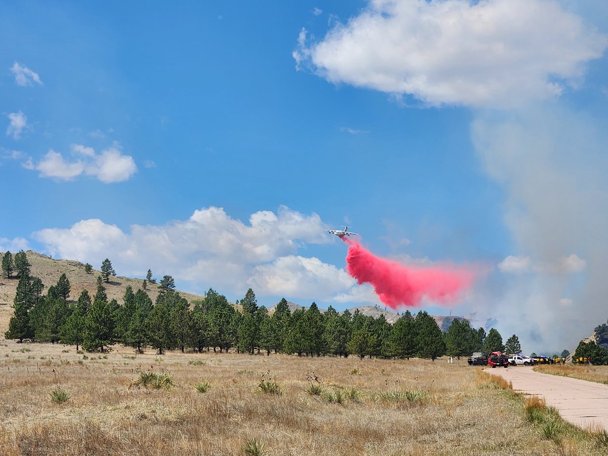
South Fork Fire Report — June 11, 2026
Fire Start, Size and Growth
Start Date/Time/Location: The South Fork Fire was discovered around 4:45 p.m. on Tuesday, June 9, 2026, in the Soldier Creek Wilderness of the Pine Ridge Ranger District within the Nebraska National Forest, approximately 13 miles east of Harrison in Sioux County.
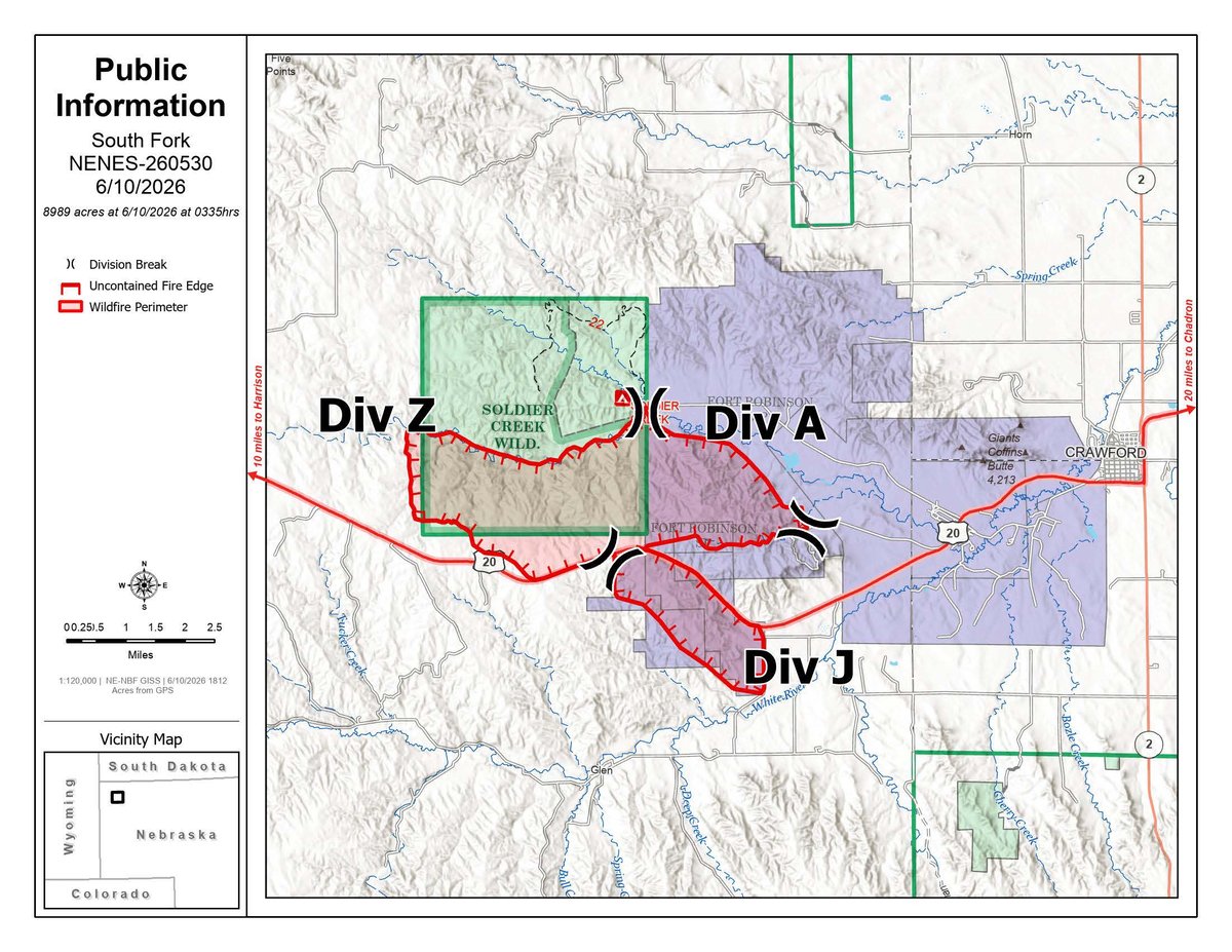
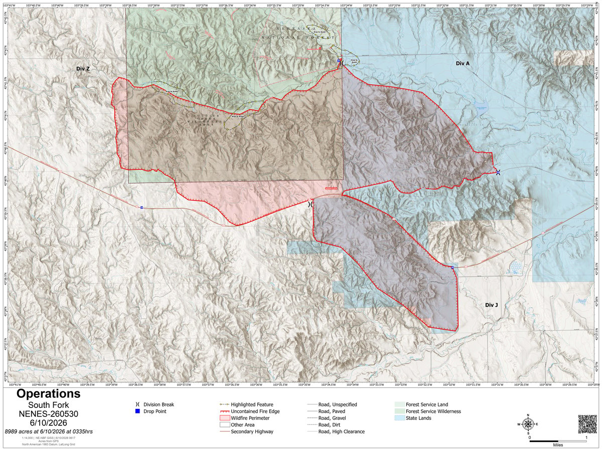
Size and Containment: As of Thursday, June 11, 2026, the fire has grown significantly to 23,112 acres and is currently 5% contained.
Fuels, Growth and Rate of Spread: Initially reported at around 500 acres, the fire grew rapidly overnight. It is being fueled by strong winds and heavy timber, including dead and downed trees left from previous wildfires. The fast-moving blaze crossed U.S. Highway 20 and has spread southeast into Fort Robinson State Park and the Peterson Wildlife Management Area.
Containment Efforts: Over 145 personnel are currently assigned to the fire, including local volunteer firefighters, federal crews, and state resources. The Rocky Mountain Complex Incident Management Team 2 has assumed command of the operations. Governor Jim Pillen has declared a state of emergency and deployed the Nebraska National Guard, including helicopter and ground units, to assist with suppression efforts.
Emergency Information
Evacuations and Sheltering:
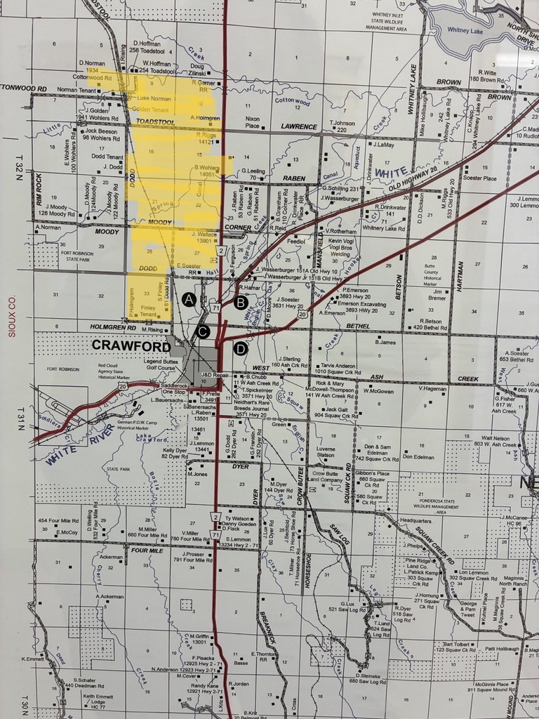
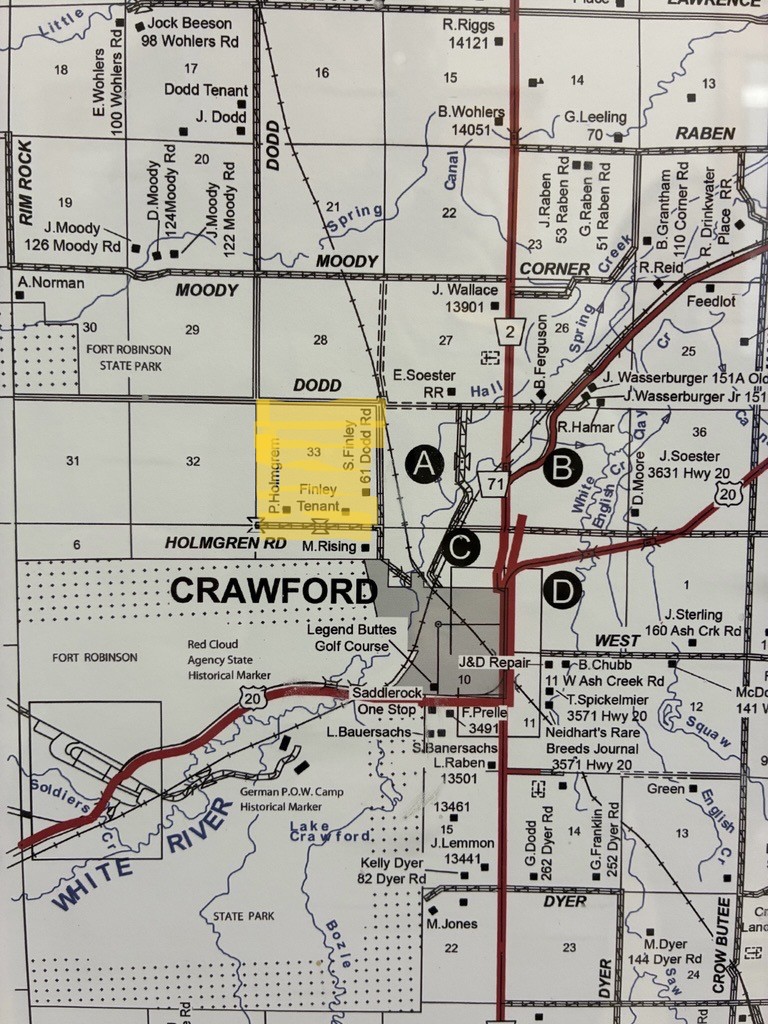
Mandatory Evacuation Orders: Mandatory evacuation orders have been issued for Fort Robinson State Park, the Ponderosa Villa assisted living facility, and portions of the city of Crawford (including areas immediately north of Crawford's city center, south and west of Dodd Road, and Dodd Road at Holmgren Road). Evacuation orders were also previously issued for the bottom of Smiley Canyon along White River Road. A total of 22 structures and approximately 95 people are currently under active evacuation orders.
Evacuation Warnings: A preliminary evacuation notice has been issued for the entire city of Crawford. Additionally, residents south of Highway 20 to 4 Mile Road in Sioux County are under a preliminary warning and should be prepared to leave at a moment's notice.
Evacuation Shelters and Information: Evacuees are being directed to Chadron, Alliance, or Scottsbluff. Region 23 Emergency Management and the Red Cross are coordinating emergency shelter options, with Andrews Hall at Chadron State College available as an emergency shelter.
Road and Infrastructure Closures:
- U.S. Highway 20 is closed and impassable between Main Street in Harrison and Nebraska Highway 71 in Crawford.
- Fort Robinson State Park is closed and fully evacuated until further notice.
For more information, visit:
- Nebraska Emergency Management Agency (NEMA)
- Nebraska 511 Travel Information
- InciWeb - National Incident Information System
Current Impact
Impacts:
Injuries and Fatalities: There are currently no reports of injuries or fatalities associated with the South Fork Fire.
Structures Impacted: While 22 structures are currently threatened and under active evacuation orders, there are no confirmed reports of structures destroyed at this time. Crews worked through the night to protect at-risk values near Crawford and Fort Robinson.
School and Business Closures: Fort Robinson State Park and the Ponderosa Villa assisted living facility have been closed and evacuated.
Notable Impacts: The fire has severely impacted Fort Robinson State Park, a major historical and recreational area, and has expanded into State of Nebraska lands. The emotional and logistical toll on the community is significant as residents in Crawford prepare for potential city-wide evacuations.
Safety Concerns:
Power Outages: No widespread power outages have been officially reported, but residents should remain prepared for potential disruptions as the fire threatens local infrastructure.
Water Safety: No specific water safety concerns have been reported, but residents should continue to monitor local advisories.
Burn Bans: The area is under extreme drought conditions, and strict fire restrictions are in place across the Nebraska Panhandle.
Air Quality: Smoke from the rapidly growing fire is impacting air quality in Dawes and Sioux counties. Residents, particularly those with respiratory conditions, are advised to stay indoors, keep windows closed, and use air purifiers if possible.
Ongoing Outlook
Containment Projections: The fire is currently 5% contained on its west end. Firefighters are focusing their efforts on the east end near Crawford to prevent additional growth and protect the community. However, containment remains extremely challenging due to the rugged terrain, heavy timber fuels, and critical fire weather.
Weather and Wind Warnings: A Red Flag Warning remains in effect for the region. Winds have been gusting over 40 to 50 mph, with relative humidity dropping into the 10%-20% range. While a recent cold front brought slightly cooler temperatures, humidity is expected to drop into the single digits by Friday, keeping fire danger critically high.
Cause and the Role of Weather and Climate
Cause: The official cause of the South Fork Fire is currently undetermined and under investigation, though local outlets have reported lightning strikes in the area on Tuesday night.
Weather and Climate: The fire's rapid explosion in size is directly tied to extreme fire weather conditions gripping the Nebraska Panhandle. The region is experiencing extreme drought conditions. High winds, exceptionally low humidity, and a landscape filled with heavy, dry timber fuels from previous wildfires have created a highly volatile environment, exacerbating the fire's intensity and rate of spread.
 View All